Accuracy vs. „Accuracy“ vs. Precision
Every once in a while accuracy is a major topic when it comes to the procurement of surveying equipment.
A surveyors opinion will always be: “ As good as possible”. There are enough uncertainties coming along and adding up.
So naturally he will always tend to the 1” or even 0.5” class of instruments.
At this point we should clarify this term: the arc second = second = “
What exactly does that mean?
Well, in easier words: Everybody knows that a circle has 360°. One degree has 60´ (minutes). And one minute has 60” (seconds). That means a full circle consists of 60x60x360= 1.296.000 seconds…
Yep, pretty much indeed. So maybe now you already get an impression of what it means if a surveying instrument can measure such tiny little angles.
But is that what accuracy is all about?
To put it in a nutshell: No, of course not! Why should it be that easy?
And this is where it gets interesting when surveyors talk to non-surveyors. The reason is that a non-professional would use the term “accuracy” whilst a surveyor would certainly differentiate:
Resolution, accuracy and precision.
There are trillions of definitions for all three terms, you just have to google them. We want to focus on a short description and differences and on what a good “accuracy” is.
So for resolution the explanation is quite easy:
The seconds mentioned above indicate the smallest change of angular movement possible to detect with this instrument. So far for that..
But what about the other two?
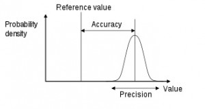
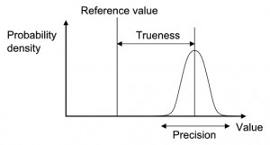
One of my favorite definitions for accuracy and precision is the following:
Accuracy and precision are defined in terms of systematic and random errors. The more common definition associates accuracy with systematic errors and precision with random errors. Another definition associates trueness with systematic errors and precision with random errors, and defines accuracy as the combination of both trueness and precision.
Ok, this is where it gets frustrating for most of the non-professionals. So lets stick with these “easy” definitions and focus on what you need for your job.
Again, the answer can not be given and true for all cases in question here. What we learn is that the seconds which non-surveyors think is the accuracy is better described by the word resolution of the surveying instrument.
What they mean when using the term accuracy is more likely to be a mix of precision, trueness and accuracy.
How can we make use of this knowledge? Well, it might be good to know when checking your requirements according to the task you have to perform.
While control measurements of the tunnel lining or for segments require the highest resolution possible, automated use of surveying instruments e.g. guidance systems might as well use lower grades of resolution (commonly 2”-5”).
Of course your question is: Why? Well, with most of the automated measurement systems you also get other variables acting as bottlenecks influencing your displayed result. String or angle sensors for example. The problem here is that their resolution is much lower than the one you get with your surveying instrument.
As these sensors are used on moving objects, your targets on these objects are probably moving too. So the question is not “How accurate can my instrument survey my targets, 1 or 2mm?” but rather “How can it even measure reliable values while my targets are jumping around like little Duracel rabbits?”
Well, there we have another fancy technology that helps us with that… But this is not to be covered in this blog entry.
What you should know when you have to decide for one of the above mentioned resolutions:
- The more precise, the more expensive
- 5” = 0,00138°
4″ = 0,00111°
3″ = 0,00083°
2″ = 0,00055°
1″ = 0,00027°
Yes, you are right: 5” is just 1/1000 of a degree…
As you may see the question when selecting/purchasing your next guidance system or monitoring system is not only the precision you will get, , but the overall accuracy and additional features like reliability, robustness,service, to name a few .
And for sure on the task you want your equipment to do.


